Transport for a world city   |   Study

Transport Connectivity

Updated:

Data measuring the connectivity within (intra-urban), and between (inter-urban), different places.

Published: Tagged: PlaceTransport

Transport Connectivity

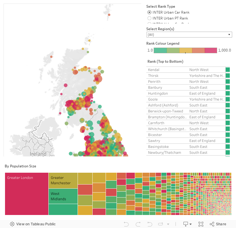
The Commission worked with Prospective Labs to construct a set of measures of transport connectivity. These measures assess the ease with which people can get around within (Intra-urban connectivity), and between (Inter-urban connectivity), different places in Great Britain. This analysis was used to inform the Commission’s recommendations on urban transport, and key conclusions driven by the measures were included in the National Infrastructure Assessment.

Intra-Urban and Inter-Urban Connectivity

This interactive map provides more detailed spatial results from the scenario modelling and analysis. It shows peak travel time intra-urban connectivity (connectivity within places; by car, by public transport and across both modes normalised by population) and; inter-urban connectivity (connectivity between places; also, by car, by public transport, and across both modes normalised by population).

For further information on how these measures presented here have been constructed, users should refer to this discussion paper, published by the Commissions which sets out the detailed methodology and findings.

All transport connectivity data

All of the connectivity data can be downloaded here.

Download data files
Tower Bridget at night

Status:  Completed

Transport for a world city

The future need for large scale transport infrastructure in London and surrounding regions.

View the study

Join our team of professionals supporting the Commission to provide evidence based and forward thinking advice on infrastructure strategy.